In the early winter of 1830, the Massachusetts legislature passed an unfunded mandate that directed every town in the Commonwealth to submit a plotted survey for the purpose of compiling a new map of the state. This came only a generation after the first official state map had been printed in Boston. The history of that map, which ultimately became 2 maps involving different engravers, is a convoluted tale that won’t be discussed here.
The legislation (House Bill No. 37) indicated that each town plan sent to Boston should include accurate boundaries, public and private roads, waterways and meadows, topographical features, and “public” buildings such as mills, manufactories, etc. To generate a map of the town, Deerfield’s Selectmen chose Arthur Wesley Hoyt (1811 -1899), the 19-year-old son of Epaphras and Experience Hoyt, who went on to have a successful career as a civil engineer. Hoyt’s Deerfield plan, and others he did for area towns such as Conway and Northfield, is in the Massachusetts Archives at Columbia Point, Boston.
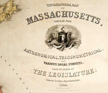
For the sake of accuracy, a trigonometric survey incorporating measurements made with a theodolite would be used to create a base map on which to plot the town surveys. Work on the former began in 1831 after Simeon Borden, then an assistant surveyor on the project, fabricated an instrument capable of minutely measuring the length of a line of more than seven miles from which all subsequent trigonometric measurements would be made. As work continued it became clear that many of the surveys sent by towns lacked geographic or topographic precision, a situation that increased the work required by the state’s surveyors. Not until 1844 did publication of Topographical Map of Massachusetts occur, with Simeon Borden named as superintending surveyor. A generous donor presented a copy of the map to Historic Deerfield in 2010.
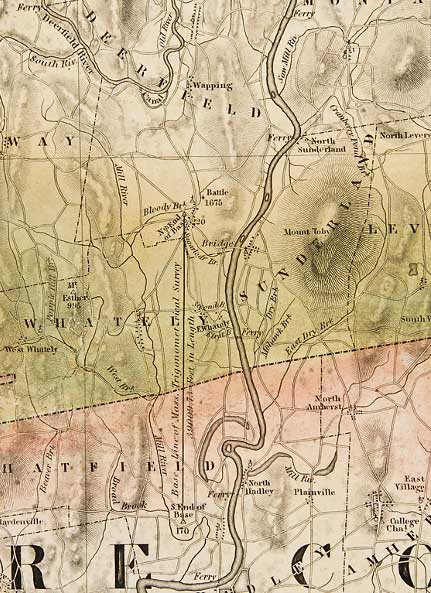
Three years before the map’s publication, Borden wrote an account of the survey that was published in the Transactions of the American Philosophical Society. The surveyor provided a history of the project along with numerous technical details. He noted that the base line, from which all other measurements originated, had been laid out “on the Connecticut River,” and had a length of 39,009.73 feet. In fact, the survey began in the town of Deerfield. A marker commemorating the site sits on the lawn of the Tilton Library in South Deerfield, and notes that the beginning point of the survey lies 3,000 feet to the west. Borden described the location as “situated in a lot of land upon the south bank of Bloody Brook.” The terminus of the base line was “near the middle of a field belonging to Josiah Ellis” in Hatfield.
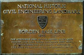
James Stevens, who initially supervised the survey, apparently selected the site of the critical baseline. No explanation, however, of why Deerfield and Hatfield were chosen gets mentioned in any survey reports or memoirs. Of course their activity didn’t escape local notice. The Greenfield Gazette & Franklin Herald of August 23, 1831, contained a brief report written by someone who had visited the site. The correspondent concluded that the accuracy of the baseline would be “a proud and lasting monument to the intelligence and liberality of Massachusetts.” One wonders if Arthur Hoyt was also observing as the state surveyors did their work.